Dimitris E. Tsopanis
Rural & Surveying Engineer
Reliable and complete services for your property.
- Georeferenced diagrams in GGRS '87
- Unauthorized constructions, Law 4495/2017
- Electronic Building / Plot Identity
- Energy Certificates
RURAL & SURVEYING ENGINEER N.T.U.A.
WHO WE ARE
Your surveying engineer from the first measurement point to the final delivery of your project.
The topografos2023 technical office has been operating since 2005 under the direction of Dimitrios Tsopanis, son of Evangelos, Rural and Surveying Engineer (NTUA).
The main office is in Porto Rafti, in the Municipality of Markopoulo Mesogaias, and there is also a second service office in the Municipality of Petroupoli.
The topografos2023 technical office undertakes all the services required for your property, from field measurement to the electronic submission of the file. With modern field and office equipment and many years of experience (over 20 years), we focus on accuracy and on keeping the owner properly informed.
- Field measurements with modern instruments
- Complete handling, from measurement to submission
- Clear information on every step and on the cost
- The topografos2023 technical office serves all of Greece and has a large network of associates (engineers, lawyers, a geologist, real estate agencies, notaries, an accountant).
SERVICES
Our services for the complete handling and fulfilment of your property's needs.
Georeferenced topographic diagram
Drawn up in GGRS ’87 for property transfers, building permits, the Cadastre and public services.
Boundary surveys and setting out
Property boundary demarcation and detailed setting out for construction works.
Elevations and volumes
Calculation of elevations and volumes for excavations, fills and studies.
Construction site support
Surveying support at every stage of the project, from foundations to handover.
Photo interpretation
Interpretation of aerial photographs to document the past appearance and use of a property.
Cadastre
Cadastre-related work and Geometric Change Diagrams.
Electronic Diagram Code (K.H.D.)
Issue of the electronic diagram code for your property.
Floor plans, elevations and sections
Floor plans, elevations and sections for surveying existing structures.
Unauthorized constructions under Law 4495/2017
Regularization of unauthorized constructions: bringing unauthorized structures under the provisions of Law 4495/2017, with full technical support.
Issue of Energy Performance Certificate (E.P.C.)
Issue of an energy performance certificate for the transfer, sale or rental of a property.
Electronic Building Identity (E.B.I.)
Issue of the electronic building / plot identity, with proper documentation of the property's details.
Can't see what you're looking for?
Tell us what you need and we will get back to you as soon as possible.
HOW WE WORK
Clear steps, no surprises
The aim of the topografos2023 technical office is to assess and find the best solution for your property.
01
Contact
You call us or fill in the form and we discuss what you need.
02
Documents / plans
We examine the property documents and give you a clear quote.
03
Measurement and drafting
The diagrams needed for your file.
04
Delivery
We deliver the complete file in printed and digital form.
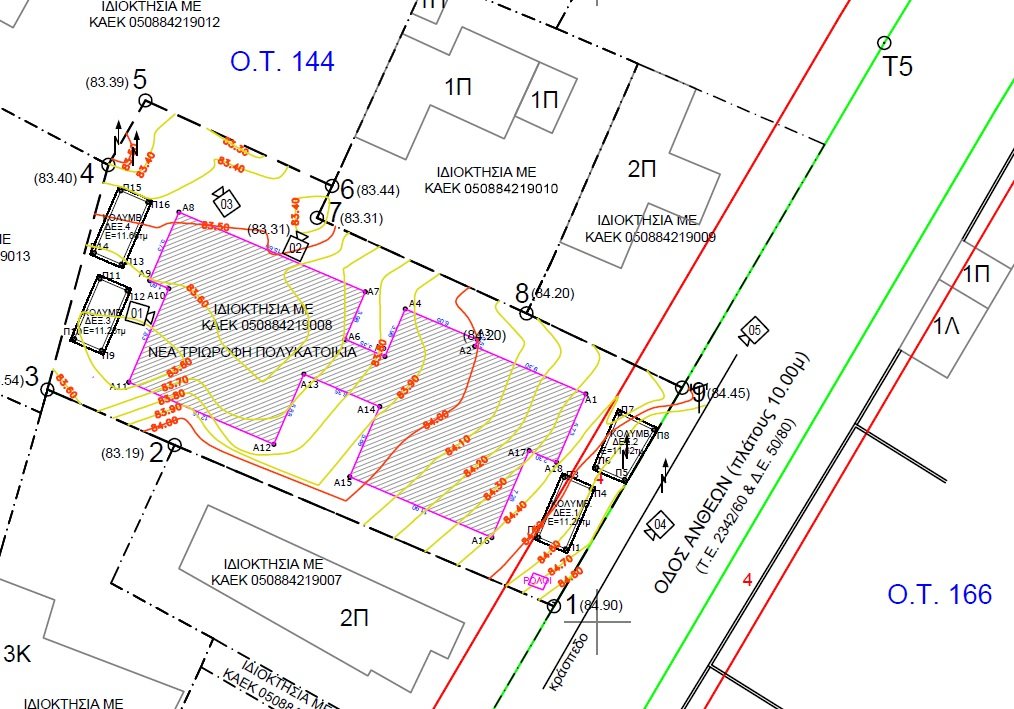
Extract of a topographic diagram for a building permit, with contour lines and the position of the future building.
FAQ
Answers before we start
The most common questions from property owners. If you can't find the answer you are looking for, call us.
The topografos2023 technical office serves all of Greece
What is needed to prepare a topographic diagram?
Before our first meeting, to prepare the topographic diagram of your property we will need the title deed, the National Cadastre number (KAEK) or a pin from Google Maps, and the owner's details.
When is a georeferenced topographic diagram needed?
For property transfers, when issuing a building permit, for work involving the Cadastre and in procedures for regularizing unauthorized constructions. The diagram is drawn up in GGRS ’87 and records the boundaries, the area and the existing buildings of the property.
How much does a surveying job cost?
The cost depends on the area, the location, the terrain and the intended use of the topographic diagram. After our first meeting and the review of your documents / plans we will be able to give you a clear estimate of the cost of our services. You can request a quote here.
Do you also submit the file to the authorities?
Yes. We handle the electronic submission of the file to the competent authorities and keep you informed at every stage.
When do I need an Energy Performance Certificate (EPC)?
It is required for the sale (a document that accompanies the electronic property identity) or for the rental of your property. The E.P.C. is valid for 10 years. If you are not sure about your case, ask us and we will guide you.
What is needed to issue an energy certificate?
A surveying engineer usually needs the plans or dimensions of the property, the title deed and details about heating, cooling and window frames. Where necessary, we carry out an on-site inspection and collect whatever is missing.
Which areas do you serve?
The topografos2023 technical office serves all of Greece. Contact us.
GET STARTED TODAY
Do you need a surveying engineer?
Call us or send a message. From our first contact we will tell you what is needed and how we proceed.
CONTACT
Tell us what you need
Send us a message or call us. The surveying engineer will reply as soon as possible.